Drone Construction

Construction

Aerial Innovators - Florida's Leading Drone Photography Company - Orlando

Florida's Leading Drone Construction Provider

As one the Best Drone Construction service provider in Florida, Aerial Innovators leverages cutting-edge drone technologies for top-notch imaging and aerial data collection. 

Our services empower construction companies to manage resources effectively, make informed decisions with accurate data, track site progress efficiently, provide methods to share updates with investors and customers, enhance workplace safety, and save money throughout the process. 

The drone revolution is just commencing, and all organizations involved in the construction industry will benefit from the latest aerial data collection.

Drones Used In Construction Stats

1 %

Companies planning to expand drones use beyond aerial mapping

1 %

Construction utilizing drones in some form

1 %

Drones being used in projects YOY

Top Drone Construction Photography Company in Metro Orlando

Aerial Innovators - Aerial Construction Service - Orlando

Data collected by drones can be useful in all phases of construction: bidding, pre-planning, design, execution, maintenance, and asset protection.

Aerial photography should be an essential part of every new construction project.

Drone photography is a useful tool in construction projects due to its many benefits. Firstly, 2D maps help in monitoring progress on the construction site. Secondly, 3D models provide easy visualization of the construction from every angle. Thirdly, elevation maps help in checking drainage. Lastly, stockpile annotation reports ensure that contractors are delivering the correct amount of materials.

Using a drone for construction provides:

  • On-demand image acquisition.
  • Comprehensive and accurate data & measurements.
  • Significant time & cost savings.
  • Improved documentation.
  • Remote access.
  • Safety.


DRONE BENEFITS IN CONSTRUCTION​
Aerial Innovators - Enhanced Safety

Enhanced Safety

Drones conduct hazardous site inspections, minimizing the need for workers to access dangerous areas.

Aerial Innovators - Cost Savings

Cost Savings

Automated drone tasks reduce manual labor and time, leading to significant cost savings in construction projects.
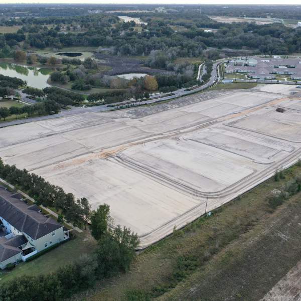
Aerial Innovators - Drone Construction Provider Orlando

Efficient Surveying

Revolutionizing surveying processes, drones deliver swift and precise data, invaluable for accurate construction site mapping.

Aerial Innovators - Construction - Communication

Improved Communication

Aerial imagery enhances communication by providing clear visual data for effective collaboration among project stakeholders.

Aerial Innovators - Construction - Monitoring

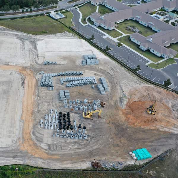
Real-time Progress Monitoring

Aerial views from drones enable real-time monitoring, allowing project managers to promptly address issues and keep construction on schedule.

Enhanced Project Collaboration

Real-time aerial data sharing fosters collaboration among project teams, optimizing coordination with teams for ideal outcomes.

Our Latest Work

Construction Drone Services & Aerial Mapping

At Aerial Innovators, we focus on drone construction monitoring. Our goal is to improve everyday processes to help save time and money. While providing important data that might be hard to get otherwise.

Our services integrate with various construction management applications. Elevate your construction projects with our advanced drone solutions.We can integrate with several construction management applications.

Aerial Innovators Construction Drone Services

Aerial Innovators - Drone Construction Provider Orlando - Orlando

If You're Unable Measure It, You'll Be Unable Manage It​

Land developers, property condition assessment, and architectural engineering firms use drone technology. Whether to decrease project times, reduce overall costs, and/or provide timely, detailed, accurate survey-grade results. That equals or exceeds traditional methods. 
Regular drone mapping updates keep projects on track and allow all stakeholders to collaborate in a 3D environment during all development phases. 
Aerial Innovators is committed to safety and creating high-quality data products for builders, land developers, and general contractors. 

Our Strategy Planning Process

Pre-Planning

3D maps, aerial still shots, and aerial video of your construction site can help you plan your project so that you notice potential problems before they worsen.

Reporting​

Customers appreciate regular project updates, but on-foot site surveys are time-consuming. By leveraging drone video, images, and construction-focused software, we efficiently generate reports for swift sharing with customers and stakeholders, significantly reducing manual effort.

Safety

Drones offer a full site view, aiding in the identification and resolution of safety issues, eliminating the need for extensive on-foot exploration.

Tracking the Progress​

Many construction projects run over their projected budget due to unforeseen delays. Our drone data lets you track progress in real time, helping you identify problems before they develop into significant issues.

3D & Orthomosaic Maps

We can create 3D and orthomosaic maps for you, which can be used for all of the above purposes, as well as for measuring stockpiles on site, looking at potential elevation and drainage issues, and more.